The Dutch enjoy a hard-earned
reputation for building river dikes and sea barriers. Over centuries, they
have transformed a flood-prone river delta into a wealthy nation roughly
twice the size of New Jersey.
If scientific projections for global warming
are right, however, that success will be sorely tested. Globally, sea levels
may rise up to a foot during the early part of this century, and up to
nearly three feet by century's end. This would bring higher tidal surges
from the more-intense coastal storms that scientists also project, along
with the risk of more frequent and more severe river floods from intense
rainfall inland.
Nowhere does this aquatic vise squeeze more
tightly than on the world's densely populated river deltas.
So why is one of the most famous deltas
the Netherlands breaching some river dikes and digging up some of the
rare land in this part of the country that rises (barely) above sea level?
In the Biesbosch, a small inland delta near
the city of Dordrecht, ecologist Alphons van Winden looks out his car window
at a lone excavator filling a dump truck with soil. He considers the question
and laughs. "We do have a hard time explaining this to foreigners,"
he says.
The work here represent a keystone in the
country's climate-adaptation plans, Mr. van Winden says. Indeed, nowhere
are adaptation planning efforts to address rising sea levels and flooding
more advanced than in the Netherlands.
To be sure, the country's economic wealth
and long experience dealing with threats from seas and rivers give it an
advantage over other low countries that face rising waters, such as Bangladesh,
Vietnam, and the tiny tropical island nation of Tuvalu in the South Pacific.
But many of the approaches the Netherlands is taking can and are being
slowly adopted even in countries far poorer, specialists say.
The excavation work here is one example of
what van Winden calls "soft approaches" to flooding in this small nation
where competing interests jostle for every square foot of land. By buying
out the few farmers remaining in this region, breaching the dikes they
built to protect their land, and digging additional water channels, the
Dutch government aims to reduce peak flood flows at Dordrecht and other
cities downstream. No longer will tightly constricted river and canal channels
hold high water captive. Big floods will overspread the Biesbosch, reducing
the threat of water spilling over the top of levees that guard densely
populated cities to the west.
The Biesbosch may also be critical to the
future of farming on the productive southwest coast. There, most of the
area's fresh water sources are close to the coast and vulnerable to salt-water
contamination from a rising North Sea. This could make farming difficult,
if not impossible. The Biesbosch, however, hosts three large reservoirs,
each surrounded by a 20-foot-high dike. Fresh water piped from these reservoirs,
some 50 miles inland, could keep coastal areas supplied.
1.4 billion live near seacoast
Globally, some 21 percent of the world's 6.6
billion people live within 20 miles of a seacoast and nearly 40% within
60 miles, says Robert Nicholls, a professor of civil and environmental
engineering at the University of Southampton in England.
Seacoast populations who face the greatest
risk from floods, storms, and sea-level rise live on river deltas, says
the UN- sponsored Intergovernmental Panel on Climate Change.
In the IPCC's latest set of reports on the
impact of global warming, released earlier this year, scientists looked
at data from 40 of the globe's river deltas, home to 300 million people.
If current trends continue through 2050, flooding in the Nile, Mekong,
and Ganges-Brahmaputra river deltas could each displace more than 1 million
people. Up to a million more may be forced to head for higher ground in
each of another nine deltas, including the Mississippi River delta. Up
to 50,000 could be forced to relocate in each of 12 other deltas, including
the Rhine River delta an area known more widely as the Netherlands.
Besides global warming, scientists say the
challenges these regions face have other causes as well. Levees, sea walls,
drainage canals, dams, and other land-use patterns have taken a toll. Deltas
tend to subside (sink) naturally, accentuating the rise in sea level. Past
engineering projects can actually limit the ability of natural processes
to replenish the land mass of deltas.
A patch of the Netherlands between Rotterdam
and Gouda, called Zuidplaspolder, highlights the issue in a way
that New Orleans might recognize. The 19-square-mile area is bounded by
dikes and the Gouwe River. Face the river, and the landscape looks like
a typical river plain. But turn and face Zuidplaspolder, and
you see a steep decline dropping more than 20 feet. The huge dimple in
the delta stretches as far as the eye can see.
It's the lowest spot in Europe, some 23 feet below sea level.
"And it's all subsidence," says Willemien
Croes, a planner with the provincial government of South Holland. Over
the centuries, residents dug up thick layers of peat to warm their homes
in Gouda, Rotterdam, and Amsterdam, she says. Much of Zuidplaspolder then
filled with water. Farmers pumped it dry, grew crops, and raised dairy
herds on the rich clay and peat. When the soil settled, farmers ringed
the area with dikes for protection.
The area's low elevation and the anticipated
increased future risk of floods, combined with development pressures from
Rotterdam and Gouda, have turned this area into one of the country's biggest
adaptation challenges. But it's hardly alone: Some 60% of the country,
accounting for 70% of its gross domestic product, lies below sea level.
These sinking lowlands are protected along
the coast by sand dunes, dikes, and sea barriers that stretch across the
mouths of estuaries. These natural and engineered defenses have protected
millions from the North Sea since a devastating storm surge hit the country
in 1953. But these defenses have come at an ecological cost. Unlike river
deltas such as the Mississippi's, which grew as sediment washed downriver
from deep in the North American interior, the Dutch delta was built by
the sea. Currents swirling through the Strait of Dover since the end of
the last ice age eroded the white cliffs and deposited the material along
the Dutch coast.
That process has slowed substantially, says
van Winden, who works for Stroming, an environmental consulting firm in
Nijmegen. Although the delta drains three of Europe's major rivers the
Rhine, Meuse, and Scheldt the rivers never carried enough sediment to
build the delta, and don't carry enough silt to maintain it today. From
that standpoint, he says, over the long term "we are living beyond our
means."
Dutch humble in face of rising threat
Faced with the twin threats of increased river
flooding from inland storms and higher ocean storm surges as the climate
warms and sea levels rise, the country aims to meet these challenges with
a variety of approaches, ranging from complex engineering to "natural."
But it's doing so with increased humility, given the levee failures in
New Orleans after hurricane Katrina in 2005.
"If you want a caricature of the Netherlands,
it's: 'We have the dikes; we are 100% safe. So just go on with your life"
says Pieter Bloemen, who runs the government's Adaptation Program for Spatial
Planning and Climate. But these days, "even we proud Dutch, with climate
change in the back of our heads, have to think about broken dikes. That's
a big paradigm shift."
Zuidplaspolder is a case in point. As the lowest
real estate in one of the Netherlands' most vulnerable provinces, it has
become a test bed for factoring water and climate change into zoning and
development plans. In the next 20 years, 15,000 to 30,000 new housing units
will be built here. Anticipating this growth, in 2004, officials from provincial
and local governments joined with nongovernmental organizations to develop
a master plan for the polder. (A polder is a large tract of land containing
farms and villages encircled by dikes. The dikes offer flood protection,
but they also turn the polders into enormous bathtubs with bottoms that
slowly, inexorably sink.)
The new homes that rise in the polder may
look nothing like those in the villages the Dutch are used to, Mr. Bloemen
says. To deal with floods, homes on this higher ground could be designed
to float in place or built on stilts. They may sport tall ground floors,
with living space and utilities placed on higher floors. Entire villages
might be built to float in place, linked by buoyant sidewalks and roads.
In addition, he adds, officials may ask developers
to use a technique that dates back centuries: building houses, even whole
villages, on mounds. That low-tech approach is appearing in other parts
of the world, too. Oxfam International is working with villages in Bangladesh
to build individual homes and even small villages on flood-resistant mounds.
In the Netherlands, river floods are a top
item on the climate-change adaptation must-fix list. To be sure, the country
has tried to be forward-looking in tackling flood control and sea-level
rise, notes Hans Balvoort, with the Netherlands' Ministry of Public Works,
Transport, and Water Management. It typically uses a 50-year planning horizon.
But a wake-up call came in the 1990s, "when, for the first time, rainfall
was so heavy and intense that our pumping systems could not cope,"
he says.
Powerful pumps long ago replaced the signature
windmills as the way to keep the polders from flooding. "On such a large
scale," he says, the inability of pumps to keep pace with rainfall was
"something we had not experienced before."
Moreover, for two winters during that decade,
flooded rivers rose so high that officials evacuated some 250,000 people
out of concern that levees might not hold. Instead of building large numbers
of new levees, he continues, scientists, engineers, and officials looked
for other ways to store flood waters over the short term to reduce the
risk.
The Biesbosch project, with its dike removal,
or "depoldering," is one approach. The government also is working
on a range of other strategies to give flooded rivers more room to flow.
They might spread dikes farther apart, excavate land between river and
dikes (to capture overflow), deepen central river channels, remove jettylike
groins that now force most of the flow into the center of a river, remove
other obstructions, and even add new channels to the flood plain or restore
old ones.
Storm surge is biggest coastal worry
The government plans to spend €2.2 billion
($3.2 billion) to make these changes to its rivers. Meanwhile, along the
coast, the big worry is not about any average increase in sea level, which
scientists project to rise here between 35 and 85 cm (14 to 33 inches)
by 2100. Instead, the biggest concern is the change in storm-surge patterns
that will ride atop that rise, says Pier Vellinga, who heads the climate
program at Wageningen University.
As if to highlight this point, last weekend
Britain and the Netherlands closed their sea barriers in the face of a
storm in the North Sea that sent a 13-foot surge bearing down on their
coasts.
Planners in other countries often design for
a once-every-hundred-years storm. While that approach can be useful, the
challenge is that climate change may throw those projections out of whack.
For example, some researchers say that in the US Northeast, midcentury
coastal winter storms could lead to flood levels every three or four years
floods of a severity that used to occur only once every 100 years. Netherlands
planners aim for a 10,000-year storm for the country's most vulnerable
areas. And even that may be inadequate, Dr. Vellinga says.
|
suite:
"When you do an economic assessment of
the damage," he says, "and what you can afford to [spend to] avoid
that damage, a better safety level would be a recurrence of 1 in 100,000
years." One storm like that could cost the country up to a year's worth
of gross domestic product €500 billion ($730 billion).
In 1990, the government decided to maintain
the country's existing coastline by replenishing its extensive phalanx
of coastal dunes using enormous deposits of sand that lie far offshore
another geological gift delivered over millennia from the English Coast
to the Netherlands.
Three years ago, the government added that
it will strive not only to maintain the coastline at its current position,
but also to maintain the shape of the current offshore slope to a depth
of about 130 feet. Today, that means dredging and depositing nearly 16
million cubic yards of sand along the coast each year. So, as the sea level
rises, the dunes will, too, says Joost Stronkhoorst, with the National
Institute for Coastal and Marine Management at The Hague.
Offshore sand deposits are large enough to
allow the Dutch to accommodate a rise in sea level up to 16 feet, he says.
But the line of coastal dunes is not unbroken. The gaps are spanned by
barriers that in some cases will require 20 feet added to their height
given sea-level-rise scenarios out to 2100.
In some cases, that's not possible. The northern
coastal town of Petten shows why. It's tucked hard against the back of
a sea dike that traces its origins to the Middle Ages and sits 14 feet
below the level at which waves crash on the other side.
To build up a dike, you must expand its base,
explains Roel Posthoorn, with the Dutch nature trust Natuurmonumenten,
as he stands on the crest of the dike on a blustery fall afternoon. The
presence of the village eliminates the chance to expand the dike's base
inland. And churning North Sea currents already sweep away precious coastal
sand from the seaward edge of the dike's base, preventing planners from
trying to expand the dike seaward.
Possible solution: artificial reefs
Here, Mr. Posthoorn says, the long-term solutions
may lie in building an offshore reef to reduce the height of the waves
slamming into the dike. Or, as some are now beginning to suggest, perhaps
the large deposits of sand offshore should also be used to build the country's
coast westward by nearly a mile.
In the meantime, groups like Natuurmonumenten
are working to meet two of the country's adaptation goals by trying to
prevent further development behind sea dikes like this one and converting
the land to nature reserves. These "climate buffers" are another
tool in the Netherlands' kit for coping with global warming.
Adaptation experts generally agree that scientists,
engineers, and policymakers already know what needs to be done to adapt
to global warming. For the most part, they say, it means doing what they
already know how to do to reduce risks from natural hazards it's just
doing more of it and a better job of it.
As if to underscore the point, Henk Wolfort,
a researcher at Alterra, an institute at Waganingen University that focuses
on sustainable development, shows a set of maps illustrating the evolution
of watery areas and polders in the country since the 14th century.
"Our problems are not so very different
from the problems the people in the Middle Ages had," he says. Even
back then, techniques like building on mounds or widening the space between
river dikes to accommodate flooding were well understood. The lesson? In
a high-tech age, some of the effective adaptation approaches may come from
a decidedly low-tech time.
"I think the people in the Netherlands
have forgotten about those old ideas because they have relied on technological
solutions," he says. "Now they see that technical solutions don't provide
100% safety. So perhaps we should think about the old solutions again."
Le combat obstiné des
Pays-Bas contre les eaux
http://www.la-croix.com
Avec le réchauffement climatique,
le pays dont la moitié de la surface est sous le niveau de la mer
doit imaginer de nouvelles solutions pour lutter contre la montée
des eaux
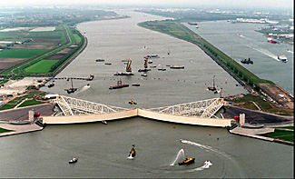
Ils étaient près de 2.000, le
9 novembre, sur les berges d'Hoek van Holland, petite localité battue
par les vents de la mer du Nord à l'embouchure de l'estuaire du
port de Rotterdam. Venus de tous les Pays-Bas en cette soirée de
grande tempête où le niveau des eaux était monté
de plus de trois mètres, ils voulaient voir se refermer la grande
barrière de Maeslant.
Pour la première fois depuis 1998,
date de l'achèvement de sa construction, le gigantesque mécanisme
était articulé dans des conditions réelles de danger.
En deux heures, les deux grands bras de métal et de béton
d'une longueur équivalant chacun à la hauteur de la tour
Eiffel se réunissaient au-dessus des flots déchaînés.
Puis, ses caissons se remplissant d'eau, ils
s'enfonçaient dans le cours de l'estuaire, fermant durant quelques
heures la navigation et évitant tout danger d'inondations pour un
million d'habitants en amont. «Nous n'étions pas sûrs
de nous, la barrière n'avait été manuvrée
que pour des exercices. Le succès ce vendredi-là fut complet»,
raconte encore plein de fierté Tim Geluk, chargé de l'information
du site.
Six ans de travaux
C'est au début des années 1990
que l'idée de la barrière s'est imposée, plutôt
que celle de rehausser une fois de plus les digues. Les travaux ont duré
six ans et coûté 680 millions €. Le 9 novembre, alors
que, pour la première fois depuis 1976, les services de surveillance
des digues étaient mis en alerte sur l'ensemble des côtes,
un porte-parole du ministère des transports estimait que la violence
de la tempête avait approché celle de 1953, qui avait fait
près de 1.800 morts et 72.000 déplacés.
Dans les jours suivants, l'Union des assureurs
néerlandais chiffrait les dommages à 500.000 €, bien
en deçà du coût des dernières inondations «classiques»,
en janvier 2007, qui avaient causé 330 millions de dégâts.
Quelques chiffres expliquent le combat éternel
contre la montée des eaux que livrent les Pays Bas, battus par la
mer du Nord à l'estuaire de trois fleuves (Meuse, Rhin et Escaut):
55 % du territoire, occupé par 65% de la population, est sous
le niveau de la mer. L'ensemble est aujourd'hui protégé
par plusieurs milliers de kilomètres de dunes ou de digues.
"Le vrai gouvernement, c'est le service des eaux"
En cinquante ans, le pays a connu, outre 1953,
trois autres alertes majeures en 1993, 1995 et 1998 dues, cette fois,
à la montée des eaux des fleuves et à la force des
pluies. Le pays continue à investir pour se protéger (cinq
à six milliards € d'ici à 2020). «Chaque année,
explique Marieke Dirkson, du service des eaux du ministère, 12 millions
de mètres cubes de sable viennent renforcer les digues (contre 8
millions en 1990), un sable en partie puisé en haute mer, car il
est jugé plus solide.» Quant à la montée
des eaux due au réchauffement du climat, «elle est estimée,
ajoute-t-elle, entre 35 et 85 cm d'ici à
2100».
Pour se rendre visuellement compte du travail
effectué en cinquante ans, il faut rejoindre la Zélande,
la région sud qui était entièrement sous les eaux
en 1953. Adam Wijnands, ingénieur, sera notre guide. Né à
100 mètres derrière les dunes qui protègent La Haye,
il avait 9 ans en 1953 et se souvient des récits, à l'école,
de cette tempête meurtrière. «Depuis, le vrai gouvernement
du pays, c'est le Rÿkeswaterstaat, le service des eaux»,
affirme-t-il.
De Rotterdam à Burgh Haamstede, au
bord de l'Escaut, on a beau traverser de multiples bras de rivières,
passer d'une île à l'autre, on a l'impression de se trouver
en pleine campagne. Partout, l'horizon de cette région agricole
bute sur de douces collines des centaines de kilomètres de digues
d'argile et d'asphalte qui suivent la pente des eaux ou se dressent face
aux vents , partout des stations souterraines de pompage ont pris le relais
des moulins à vent. Même Zierikzee, que tient à nous
faire traverser notre guide, complètement inondée en 1953,
a effacé ses cicatrices.
Pont gigantesque
«Le fameux plan Delta a fermé
par sept barrages, entre 1958 et 1972, tous les bras de mer du sud-ouest
du pays, à l'exception des routes maritimes menant à Anvers
et Rotterdam.»
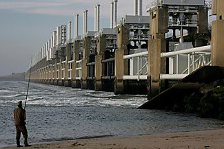
Pour trouver la trace de 1953, il faut enjamber
le barrage anti-tempête construit sur l'Escaut oriental. Un pont
gigantesque coupé par l'île artificielle de Neeltje Jans.
Là, à côté du musée qui garde avec
d'émouvantes lettres, des photos et des objets anonymes le souvenir
de cette nuit tragique du 31 janvier, se tient le centre de commande de
l'édifice. Le pont comprend 62 vannes d'acier, édifiées
à plus de 15 m sous la mer, qui s'abaissent en cas de danger.
«Depuis 1986, date de son achèvement,
explique Ted Sluijter qui a suivi l'évolution de la barrière,
elle a été utilisée 26 fois, 24 pour se prémunir
contre la mer du Nord et deux fois pour se protéger contre la montée
des eaux du fleuve.»
La menace est toujours là
Car la menace est toujours là. «
Les digues sont perpétuellement inspectées », explique
Margriet Roukema, du service des eaux, citant les 97 chantiers destinés
à renforcer les endroits préoccupants. Un coût total
évalué à 2,7 milliards €. Certains de ces travaux
ont commencé, comme à Noordwijk au nord de La Haye.
D'autres sont encore à l'état
de projet. Comme à Scheveningen, le quartier de La Haye situé
le long de la mer. Pour rehausser cette digue usée par les tempêtes
12 m au lieu de huit , le projet d'une nouvelle route qui ne fasse pas,
comme aujourd'hui, injure à la beauté époustouflante
de la mer du Nord, a été confié à l'architecte
espagnol Manuel Morales. Un tracé en courbe sur différents
niveaux un peu comme un théâtre dont la construction devrait
commencer en 2009. À condition de trouver les fonds.
70 millions € seront financés
par l'État mais les 25 autres destinés à l'esthétique
urbanistique sont à la charge de la mairie. «La moitié
a été mise de côté», explique Hans
Alewijnse, ingénieur à la ville qui espère une rallonge
gouvernementale.
Retour à la nature
Le pays peut-il indéfiniment
continuer à ce rythme financier? «Depuis cinquante
ans, on a privilégié les immenses travaux publics, mais avec
l'impact du réchauffement du climat, il faut imaginer autre chose»,
soutient Ellen Verkoelen, la présidente de Milieufederatie, organisme
regroupant 350 ONG environnementales. «On ne peut pas avoir des
digues qui montent jusqu'au ciel.»
Une commission réunissant associations,
experts et pouvoirs publics prône maintenant un retour à la
nature en laissant à la flore sauvage, le long de la côte,
le soin de jouer les gendarmes. Le premier exemple devrait, en 2008, couvrir
une bande de cinq kilomètres entre Hoek Van Holland et La Haye.
Elle pourra s'étendre ensuite tout au long du pays.
D'autres solutions sont envisagées,
car le danger ne vient plus exclusivement de la mer. Avec la montée
de l'eau des fleuves et les pluies, les stations de pompage ne peuvent
tout faire. Il faudra des bassins de rétention, arrêter l'extension
des polders. À Maashommel, à l'ouest du pays, on commence
à construire des maisons flottantes. «Bref, mêler
différents ingrédients, sans en privilégier un seul»,
conclut au ministère des travaux publics Marieke Dirkson. Le pays
se donne un siècle pour s'organiser.
Marie-Françoise MASSON
|