Part I. With much of its land below sea level,
the Netherlands is charting a course around ominous climate-change trends.
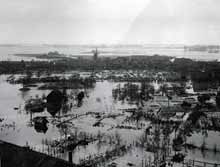
Never again: A deadly 1953 flood prompted a massive Dutch
effort to build seawalls and surge barriers. Climate change is prompting
a new shift, toward intensive flood-risk analysis and resilient construction.
This is Technology Review's second
feature examining plans for adapting to radical climate change. In our
first feature ("Planning
for a Climate-Changed World"), we described how U.S. institutions are
revisiting urban storm-surge risk assessments and making fine-scale predictions
about how disappearing mountain snowpack could devastate water supplies.
In this feature, we examine how the Netherlands deals with climate change.
This is the first part of the story; the second part will be featured online
tomorrow, June 19.
The lowest point in western Europe is 6.74
meters below sea level and falling. It lies in a boggy area of decomposing
peat outside the cheese mecca of Gouda, the Netherlands, and is identified
by a seven-meter marker plunked into a brackish pool at the entrance to
the Van Vliet truck dealership. (The dealership's owner erected the marker,
taking a little license with the facts; the actual low spot is a few hundred
meters away.) The Fodor's travel guide does not mention this corner of
Holland, but it's a focal point for the question of how to plan for
the risks and realities of climate change.
That's because the town of Gouda is considering
whether to erect 4,000 houses--some of which might float--just two kilometers
from this continental nadir. Subdivisions may rise on portions of the sparsely
developed farmland near the truck dealership, a 50-square-kilometer area
surrounded by dikes and a canal. Such reclaimed lowlands are called polders;
they're kept dry by pump houses that suck away rainwater and groundwater
seepage. The Dutch have always built on polders, but doing so now, as flood
risks rise across the country, will require new approaches that could get
an early test in this particularly low region, called the southwest polder
or Zuidplaspolder. "It sounds, sometimes, somewhat illogical," concedes
Marco van Steekelenburg, an urban planner with the regional province of
South Holland, who took me to the site. "But that is what we have to
investigate: how illogical it is. We have been given a challenge: can we
find solutions which are climate-proof?"
The country faces ominous trends as global
temperatures rise. Already, 55% of the Netherlands' land area is below
sea level, protected by a vast system of seawalls, storm-surge barriers,
and thousands of dikes that crisscross the countryside. Dutch scientists
say sea levels in the region will rise between 25 and 85 centimeters (10
and 33 inches) this century. In addition, weather worldwide is expected
to become more extreme, on average. This means a higher likelihood of flooding
along the Rhine and other rivers, and a greater risk of droughts. All the
while, Dutch land will continue to sink--at a rate of 0.2 centimeters annually
in some areas--as the peat soil underlying much of it decomposes, exposed
to air by Dutch drainage efforts.
Now, in an effort being watched around the
world, the Dutch government and several prominent research institutions
are trying to figure out how to adapt a whole country to the realities
of climate change. The Zuidplaspolder is one of several regions under consideration
for developments that float--or can float, or at least are flood
resistant. Apart from one well-hyped residential demonstration project
elsewhere in the country, though, no actual construction has yet begun.
Behind the scenes, the Dutch are taking a hard look at their growing vulnerabilities,
conducting new analyses and running computer simulations. The researchers
hope to submit a plan for adapting to climate change to the Dutch parliament
this fall and to take action on it by next year.
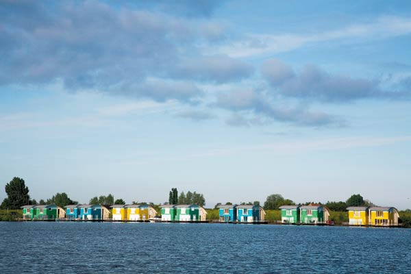 
Water world: Prototype "amphibious" houses shown here flank
a marina in rural Maasbommel. One such house (above) can rise four meters,
guided by pilings. Similar concepts await implementation until a national
climate adaptation plan is complete.
It's all about understanding risk. This means
understanding exactly how breaches in dikes and seawalls could lead to
flooding in farms and cities--how deep the waters could get and how fast
they might rise. It means understanding how those risks will change under
various conditions, such as higher sea levels and different weather patterns.
It means calculating how many people and how much property lie in the path
of such floods, and how future changes in land use could worsen or mitigate
any damage. Once they understand all that, the Dutch can plan, build, and
fortify in ways that meet specific local needs. This could mean designating
certain areas as no-build zones, developing new building techniques, adding
floatable roadways as escape routes, or replacing farms with floating greenhouses.
All this represents a major shift in focus, from preventing floods to minimizing
damage when they occur. "You are looking at a different type of planning,"
says Pieter Bloemen, a program manager with the Netherlands' National
Spatial Planning Agency.
Historically, the Netherlands--like most other
countries-- has thought about disaster protection in simple but reassuring
terms. The Netherlands' North Sea flank is sheltered by great seawalls
and tidal-surge barriers erected after a 1953 flood that killed nearly
2,000 people. The strongest of these were engineered to withstand all but
the rarest disasters: floods that have only a 1-in-4,000 chance--even a
1-in-10,000 chance--of happening in a given year.. But these probabilities
were calculated around 1960 and are understood to be obsolete. What's more,
the Dutch population surged from 11.5 million in 1960 to 16.6 million this
year, greatly raising the stakes. "Most people in the Netherlands have
the idea they are safe from flooding, because of all the investment,"
says Hans Balfoort, a senior policy advisor in the Netherlands' Ministry
of Transport, Public Works, and Water Management in The Hague. "It gives
people a false idea of absolute protection."
The Dutch program for intensive risk analysis
and planning is gaining attention in geographically similar parts of the
world, including the Mississippi River Delta in Louisiana and the Sacramento
River Delta in California. "There is a lot of pressure that places like
New Orleans should adopt this kind of approach for planning and protection,"
says Rafael Bras, a hydroclimatologist at MIT. He notes that in the U.S.,
as in the Netherlands, planners and engineers have historically focused
on the strength of seawalls and levees, not the extent of the destruction
that could occur if they failed. "In the past, our approach has been,
'We will protect to a certain-level hurricane,' without trying to translate
that into, 'What does that mean in terms of risk to the population?'"
Dams of Rotterdam
The risk analysis the Dutch are performing
requires basic information about the country's network of seawalls and
dikes, but collecting it is no easy task. Much of the nation was reclaimed
from the sea piecemeal over the past 800 years: farmers drained land, dug
canals, and built dikes, giving rise to the saying "God made the world,
but the Dutch made the Netherlands." Local democratic bodies called
water boards--hundreds of them--emerged to manage and maintain flood barriers
and pumping stations. But the accretion of locally built fortifications
did not leave a legacy of centralized, accurate records. "We are not
Swiss," laments Jaap Kwadijk, a geologist with the engineering firm
Delft Hydraulics.
To understand how un-Swiss the Dutch are,
consider the political history of the southwest polder, the area near Gouda
where the 4,000 houses may rise. Historically, a chunk of the polder was
managed by a water board called the Schieland, organized in 1273. An adjacent
water board, the Krimpenerwaard, was founded in the 1430s, cobbled
together from smaller boards. Dramatic change came in 2005. After 535 years
of peaceful coexistence, the Krimpenerwaard joined with the Schieland.
The merger is marked by a prominent sign inside the region's biggest
pump house, designating the board the "Hoogheemraadschap van Schieland
en de Krimpenerwaard." Pump-house engineer Harry Berkouwer, whose family
has lived for more than 600 years in the hamlet of Berkenwoude (its name
means "birch forest"; his means "birch cutter"), beams when
he speaks of the event.
Despite such mergers, there are still 27 separate
water boards in a country that's only about twice the size of New Jersey.
And the hodgepodge of record-keeping makes painstaking work for engineers
like Arthur Mynett, director of research and development at Delft Hydraulics
and an engineering professor at the Delft University of Technology. His
group is probing for potential failure points in existing Dutch dikes;
that requires knowing the precise height and engineering characteristics
of every one of them. "We are trying to integrate everything," Mynett
says. "If one of these dikes goes, collapses, that has an effect on
the probability that others will go. Some might have a higher, others might
have a lower probability. It is not that trivial to find out. From history,
the Netherlands is a country which is also separated in rather small administrative
units--not only the water boards, but municipalities and railroads. All
these organizations have their own databases. It's already quite an effort,
let's say, that you can even use it all."
But his group is making progress; it is now
running simulations to show how floodwater could cascade from polder
to polder, farm to farm, and street to street under various failure scenarios.
(Click
here to watch a video of the simulations.) Nathalie Asselman, a staff
hydrologist at Delft Hydraulics, gave me a demonstration with a few
clicks of a mouse. On her computer flashed a map of the city of Rotterdam.
She ran a recently created model of two possible disasters. In the
first, a major levee failed, and blue, representing water, rapidly filled
an empty area impounded by a second levee. From there, various shades of
blue--indicating different depths--trickled out slowly to parts of the
city, rising to a height of about a meter over several days. That would
be serious, but not life-threatening or city-wrecking. Then Asselman showed
what would happen if the second levee weren't there and a major storm-surge
barrier several kilometers away were left open. What unfolded would, if
it happened in real life, dwarf the New Orleans catastrophe. In a matter
of hours, much of Rotterdam was awash in blues, with flooding as high as
three meters in some areas.
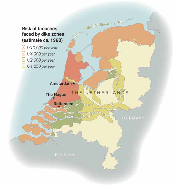
Reassessing risk: The Dutch dike system was tailored to flood
probabilities calculated around 1960. Faced with climate change and population
growth, the Dutch are now seeking systemic forms of protection, from upstream
water impoundments to floatable buildings and roadways.
Credit: Carol Zuber-Mallison
That the Dutch haven't previously tried to
understand the consequences of calamities in such detail points to the
irony of having strong defenses. No catastrophic flood has befallen the
nation since 1953. That freedom from disaster has bred complacency. "Sometimes
a plane falls down and you can investigate why it falls down," says
Kwadijk. "The trouble is, we never get any flooding, so you can't test
anything, and you can't convince the public [of the danger]." But all
that changed in 2005, when the Dutch were transfixed by the destruction
in New Orleans following Hurricane Katrina. "Katrina raised awareness
in the Netherlands," says Mynett. "To the general public, it wasn't,
'Silly Americans can't take care of water management.' It was, 'Oops--this
can happen.' It is more a feeling of solidarity."
|
suite:
Part II: The Netherlands deals with climate change.
This is Technology Review's second
feature examining plans for adapting to radical climate change. In our
first feature ("Planning
for a Climate-Changed World"), we described how U.S. institutions are
revisiting urban storm-surge risk assessments and making fine-scale predictions
about how disappearing mountain snowpack could devastate water supplies.
In this feature we examine how the Netherlands deals with climate change.
This is the second part of the story; read part
I.
Modeling the Rhine
Pinpointing weaknesses in existing water barriers
is just a first step toward understanding the Netherlands' flood risk.
Rising sea level is, of course, the elephant in the room. But for the moment,
the elephant is moving slowly enough to rank lower on the list of Dutch
concerns than certain near-term threats. One is that the Rhine could burst
its banks in areas such as Rotterdam. And as peat decomposes, land is sinking
faster than the sea is rising. (To make matters worse, peat decomposition,
triggered by centuries of Dutch land drainage, throws off greenhouse gases.)
Finally, new roads and developments could increase runoff, and population
growth could put more people in the path of disaster.
At Wageningen University's Alterra research
institute, 20 earth scientists and climate scientists are trying, among
other things, to develop an accurate way of forecasting the water level
of the Rhine. The goal is to understand the entire river as a system, from
its headwaters in the Swiss Alps, through Germany, and finally through
Rotterdam to the North Sea--to figure out how much precipitation it receives,
what hydrological processes shape it and its watershed, and how development
will change these factors. The Alterra group is trying to integrate meteorological
and hydrological models and use them to evaluate various scenarios
of climate and land-use change. "All the different components of the
model are available somewhere," says Eddy Moors, a hydrometeorologist
at Alterra. "There's a Dutch model, a German model, a hydrological model,
a meteorological model. It's a matter of finding a way to combine those
components, more than inventing something new."
One of the factors the researchers are considering
is that radical changes are expected in European land use. Dutch planners
say that by 2050, European agricultural land totaling an area larger than
Germany will give way to development or, in some cases, revert to forest.
That, in turn, will affect the way floods propagate--by altering the ability
of the land to absorb water, for example. "If we take these changes
into account and look into land use, we can perhaps promote some land-use
changes which will assist us," says Moors. "We want to see the feedback
of those changes." As part of his study, Moors has even been investigating
how trends in land use might change the local weather. By running meteorological
models, he found that turning farmland into forest is likely to stimulate
more local precipitation. Whether this is good or bad depends on whether
it happens during a summer drought or a winter flood. Either way, analyzing
such effects is important to understanding the larger system.
In addition to forecasting the effects of
changing land use, the Alterra group is trying to predict the effects of
intensified weather extremes. The Intergovernmental Panel on Climate Change,
the U.N.-sponsored body whose work represents the global scientific consensus
on the subject, recently predicted that warmer temperatures worldwide could
make droughts harsher and precipitation more intense. And in winter, precipitation
will tend to fall more as rain than snow in some areas, including the Swiss
Alps, at the Rhine's headwaters. As a result, wintertime river flooding--already
a problem in the Netherlands--could get far worse. Buffer systems of some
kind will probably be required. These might be impoundment areas upriver,
perhaps even in Germany, or underground tanks beneath Dutch developments.
But planners need to know where to put these buffer systems, and how to
manage them so they're empty when deluges are expected but full when droughts
are near. This calls for better long-range forecasts. "To adapt, it
is important to have forecasting systems," says Moors. "To be able
to do that, you have to couple meteorology and hydrology models."
Developing these sharper predictive tools
is a pursuit common to planners in The Hague, New York City, and California
(see "Planning
for a Climate-Changed World," May/June). But in the Netherlands, the
need is acute. "Our whole country is at stake," says Piet Dircke, director
of the water program at Arcadis, an engineering and consulting firm based
in Maastricht that is participating in national planning efforts. "So
we are moving from an engineering kind of approach to a systems approach.
You never know which part is going to change, and which one will be relevant,
until you look at the complete system."
Floating Houses
Once the risk analysis is complete, it will
help guide decisions on where and how to build. Development is already
restricted in some stretches of river floodplains and may soon be in others.
But with population continuing to rise, there's great pressure to develop
tracts of low-lying areas like those in the southwest polder. And besides,
defying the sea is a point of patriotic pride. "It is our culture to
cope with water," says Chris Zevenbergen, director of business development
at the construction company Dura Vermeer and a professor at the Unesco-IHE
Institute for Water Education in Delft. "Retreat would give a very bad
signal to the world. Suppose we are not building; this will have an enormous
impact on the climate for foreign investment. And from a technological
point of view, [construction] is feasible. We need to adapt to that kind
of development."
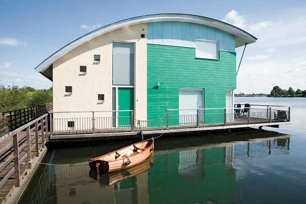
To demonstrate what is possible, Dura Vermeer
has built a floating housing development in a hamlet called Maasbommel,
in the rural province of Gelderland, near the center of the country. There,
46 amphibious houses are perched on the outer edge of a dike that holds
back the River Maas, adjacent to a marina. Sixteen are floating at the
river's edge, in conjoined pairs, with sealed hollow basements providing
buoyancy. Between each pair of houses are two vertical concrete piles (one
pile is shown below); if water levels rise, the houses rise around the
piles. Flexible water, sewer, and electrical connections are unaffected.
Thirty similar houses sit on slightly higher ground, on concrete slabs
a meter or so above the waterline. They, too, have piles and hollow basements
that will let them float if necessary. All 46 houses can tolerate a four-meter
rise in water levels. (Click
here to watch a video of the floating houses.) Though the houses have
been finished since 2006, the higher ones have not yet faced a flood high
enough to test them. "Everybody wants to see it happen. Including the
builder and the architect," jokes Cees Westdijk, who owns one of the
houses. His two-bedroom house offers beautiful water views; on the downside,
an algae bloom last year made for a nasty, if temporary, smell.

The Netherlands has designated 15 areas near riverbeds
as possible sites for amphibious developments, including variations on
the Maasbommel prototype. For the southwest polder, researchers at Delft
Hydraulics and Wageningen University have already produced the first
risk maps, showing which areas within its 50 square kilometers are most
vulnerable. National planners "look inside the dike ring and make zones
for how the water comes--fast and deep, fast and undeep, slow," says
Bloemen of the National Spatial Planning Agency. Buildings could be customized
accordingly; some might always float, others might rise and fall if needed,
and still others might simply be built to survive inundation without sustaining
major damage. "You [could] have building restrictions appropriate to
the relative dangers and flooding probabilities within each subzone,"
Bloemen says.
For the southwest polder, university and government
researchers are considering what kinds of development might be suitable.
One option is to raise water or ground levels in parts of the polder and
build amphibious or floating structures as appropriate; as a side benefit,
raising water levels would halt the decomposition of peat. Other areas
of the polder would be left at lower grades and could absorb floods. A
decision on what to do in the southwest polder is expected in the next
two years. Visions for other parts of the country include floating towns,
floatable roadways that could be used for evacuation, and tanks beneath
buildings that could hold floodwater. All of this would be a big departure
from the traditional Dutch development method: throw a couple of meters
of sand on top of the ubiquitous peat, install pilings, and pour the concrete.
Still, impressive though it sounds, erecting floating or floatable structures
is the easy part. The hard part of adapting to climate change is the planning,
which requires intensive forecasting, sophisticated modeling, and risk
mitigation strategies.
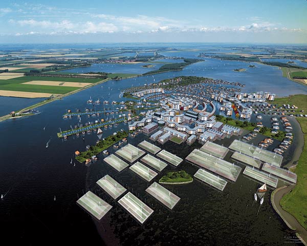
High and dry concept: A developer's vision of a floating
town, complete with greenhouses, is still just a vision. The Dutch are
doing risk analyses to decide where to build, where to forbid development,
and where to change construction techniques. To experience historical and
possible future flooding in the Netherlands, visit technologyreview.com/holland.
Courtesy of Dura Vermeer
The Dutch approach is gaining adherents around
the world. "They are taking a systems approach that includes smart development,"
says Lewis E. Link, a former director of research and development at the
U.S. Army Corps of Engineers and now a professor at the University of Maryland,
who led a postmortem federal investigation of Louisiana's levee, pumping,
and drainage systems after Hurricane Katrina. That means not just
restricting building in certain areas but being smart about how to build
in others. "I think in the U.S., we have been far too prone to let people
build in vulnerable areas that then have to be protected," he says.
"It is just a mad cycle. We have trapped ourselves into this, over and
over and over again." Part of the problem in the United States, Link
notes, is that the federal government has little control over land use,
and local governments are often unwilling to challenge developers in areas
that may face higher threat levels. In the Netherlands, the federal government
can take more control, says Balfoort. "Sometimes you must make a top-down
decision for the benefit of the nation as a whole," he observes. "You do
not discuss Christmas with the turkey."
While it's not clear whether the United States'
federal government will try to start making top-down decisions about land
use in threatened areas, at least Dutch-American research cross-pollination
is well under way. Link has just completed an assessment of the New Orleans
area--similar to the one Mynett is performing at the Delft University of
Technology--to gauge the current risks posed to the Gulf Coast by various
storm scenarios. Mynett sits on a U.S. panel making a similar assessment
of the Sacramento and San Joaquin River valleys in California.
All parties are watching to see how the Dutch
fare with climate-resilient housing. Given the dangers faced by coastal
areas and river deltas around the globe, the rest of the world may soon
beat a path to the Netherlands, clamoring for technical expertise. But
before anyone will come, the Dutch must build it. |