CONTROVERSES ENERG...ETHIQUES !
Energies renouvelables, environnement-écologie, développement, ressources technologiques...
Environnement écologie

Niveau des océans: les prédictions du GIEC trois fois trop optimistes
ADIT, février 2009
mise à jour en anglais
     Le niveau des mers pourrait s'élever d'un mètre dans les 100 prochaines années. C'est trois fois plus que ce que prédisait le GIEC, le groupe d'experts climatiques des Nations Unies. Ces résultats spectaculaires ont été publiés dans la revue "Climate Dynamics" par une équipe de chercheurs du "Niels Bohr Institute" de l'Université de Copenhague, en collaboration avec des équipes anglaises et finlandaises.
     Les rapports du GIEC prévoient une augmentation globale des températures de 2 à 4 degrés pour le siècle à venir. Mais la température des océans et la fonte des couches de glace qui recouvrent le Groenland et l'Antarctique n'obéissent pas à la même cinématique que le réchauffement atmosphérique. Ce facteur est la grande inconnue de tous les modèles prédictifs du niveau des océans. Or, comme le GIEC l'a lui-même reconnu dans son rapport de 2007, le modèle qu'il utilise pour prévoir l'élévation du niveau de la mer n'est pas capable de prendre en compte les changements rapides que les calottes glaciaires ont connu ces dernières années. Partant de ce constat, l'équipe de recherche a décidé de s'orienter vers de nouvelles stratégies de modélisation.
     "Alors que tout le monde fait des calculs à partir de ce que l'on estime qu'il pourrait se passer, nous avons décidé de faire les nôtres à partir de ce que l'on sait effectivement du passé. Nous avons ainsi tenté d'établir une corrélation directe entre température mondiale et niveau des océans" explique Aslak Grinsted, géophysicien en charge du projet au Centre de Glaciologie et Climatologie de l'Institut Niels Bohr. Le nouveau modèle est en fait une régression linéaire physiquement réaliste à 4 inconnues qui s'appuie sur les données de ces 2000 dernières années. Les paramètres de l'équation sont estimés par la méthode statistique de Monte Carlo permettant ainsi une représentation des scénarii passés et futurs du niveau des océans. Le modèle offre des capacités prédictives très satisfaisantes sur les décennies passées et anticipe l'accélération observée depuis les années 90.
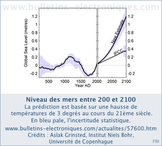
     Si l'on estime que la relation température - niveau des océans est valide de l'an 200 à 2100 au moins et si l'on se réfère aux différents scénarii de température du globe avancés par le GIEC, la hausse du niveau des océans devrait atteindre 0,9 à 1,3m d'ici un siècle. A titre de comparaison sur la période étudiée, le niveau le plus bas fut atteint en 1730 avec une baisse de 19 à 26cm par rapport au niveau actuel, alors que le niveau maximum fut atteint en 1150 avec un niveau de 12 à 21 cm supérieur au niveau actuel. Ces deux dates correspondent respectivement au petit âge glaciaire du 18ème siècle et à un pic de températures observé au 12ème siècle. Le scénario précédemment soutenu par le GIEC se révèle très improbable selon le nouveau modèle.
     Une telle élévation en un siècle à peine signifie que la banquise devrait continuer à fondre plus rapidement que prévu. Le scénario présenté par cette étude n'est pas absurde au regard de l'histoire géologique. A la fin de l'âge de glace, il y a environ 11.700 ans, la calotte glaciaire a en effet fondu tellement rapidement que le niveau des mers s'est élevé de 11mm par an en moyenne. Cette vitesse record est équivalente à une montée d'un mètre en un siècle.

Pour en savoir plus, contacts:
Aslak Grinsted, Postdoc - Ice and Climate - tél : +45 353-20591, secrétariat : +45 35 32 52 09 - email: aslak @ gfy . ku . dk
Source:
Revue Climate Dynamics : Reconstructing sea level from paleo and projected temperatures 200 to 2100 ad
http://www.springerlink.com/content/527178062596k202/
Rédacteur:
Jean-Baptiste Paquel, jean-baptiste.paquel@diplomatie.gouv.fr
Origine:
BE Danemark numéro 22 (6/02/2009) - Ambassade de France au Danemark / ADIT

Sea level rise could be worse than anticipated
    CORVALLIS, Ore. – If global warming some day causes the West Antarctic Ice Sheet to collapse, as many experts believe it could, the resulting sea level rise in much of the United States and other parts of the world would be significantly higher than is currently projected, a new study concludes.
     The catastrophic increase in sea level, already projected to average between 16 and 17 feet around the world, would be almost 21 feet in such places as Washington, D.C., scientists say, putting it largely underwater. Many coastal areas would be devastated. Much of Southern Florida would disappear.
     The report will be published Friday in the journal Science, by researchers from Oregon State University and the University of Toronto. The research was funded by the National Science Foundation and other agencies from the U.S. and Canada.
     "We aren't suggesting that a collapse of the West Antarctic Ice Sheet is imminent," said Peter Clark, a professor of geosciences at Oregon State University. "But these findings do suggest that if you are planning for sea level rise, you had better plan a little higher."
     The Intergovernmental Panel on Climate Change has estimated that a collapse of this ice sheet would raise sea levels around the world by about 16.5 feet, on average, and that figure is still widely used. However, that theoretical average does not consider several key forces, such as gravity, changes in the Earth's rotation or a rebound of the land on which the massive glacier now rests, scientists say in the new study.
     Right now, this ice sheet has a huge mass, towering more than 6,000 feet above sea level over a large section of Antarctica. This mass is sufficient to exert a substantial gravitational attraction, researchers say, pulling water toward it – much as the gravitational forces of the sun and moon cause the constant movement of water on Earth commonly known as tides.
     "A study was done more than 30 years ago pointing out this gravitational effect, but for some reason it became virtually ignored," Clark said. "People forgot about it when developing their sea level projections for the future."
     And aside from incorporating the gravitational effect, the new study adds further wrinkles to the calculation – the weight of the ice forcing down the land mass on which it sits, and also affecting the orientation of the Earth's spin. When the ice is removed, it appears the underlying land would rebound, and the Earth's axis of rotation defined by the North and South Pole would actually shift about one-third of a mile, also affecting the sea level at various points.
     When these forces are all taken into calculation, the sea level anywhere near Antarctica would actually fall, the report concludes, while many other areas, mostly in the Northern Hemisphere, would go up.
     If the West Antarctic Ice Sheet completely melted, the East Coast of North America would experience sea levels more than four feet higher than had been previously predicted – almost 21 feet - and the West Coast, as well as Miami, Fla., would be about a foot higher than that. Most of Europe would have seas about 18 feet higher.
     "If this did happen, there would also be many other impacts that go far beyond sea level increase, including much higher rates of coastal erosion, greater damage from major storm events, problems with ground water salinization, and other issues," Clark said. "And there could be correlated impacts on other glaciers and ice sheets in coastal areas that could tend to destabilize them as well."
     It's still unclear, Clark said, when or if a breakup of the West Antarctic Ice Sheet might occur, or how fast it could happen. It may not happen for hundreds of years, he said, and even then it may not melt in its entirety. Research should continue to better understand the forces at work, he said.
     "However, these same effects apply to any amount of melting that may occur from West Antarctica," Clark said. "So many coastal areas need to plan for greater sea level rise than they may have expected."
     A significant part of the concern is that much of the base of this huge ice mass actually sits below sea level, forced down to the bedrock by the sheer weight of the ice above it. Its edges flow out into floating ice shelves, including the huge Ross Ice Shelf and Ronne Ice Shelf. This topography makes it "inherently unstable," Clark said.
     "There is widespread concern that the West Antarctic Ice Sheet, which is characterized by extensive marine-based sectors, may be prone to collapse in a warming world," the researchers wrote in their report.
Editor's Note:
     Both digital images and video of the impact around the world of sea level increases up six meters can be obtained at this web site: https://www.cresis.ku.edu/research/data/sea_level_rise/index.html
     A digital image of what Antarctica would look like if it consisted only of land actually above sea level is also available at this URL: http://oregonstate.edu/dept/ncs/photos/RonneFichner.JPG
Sauvegarde resosol:
Contact: Peter Clark
clarkp@geo.oregonstate.edu
541-737-1247
Oregon State University
Dans le même domaine: Réchauffement: ultimes avertissements des spécialistes